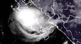
Hurricane Polo made landfall in Mexico after strengthening over the eastern Pacific, bringing strong winds, heavy rainfall and flooding risks to parts of the country. The storm’s path took it from the Pacific toward Baja California Sur before crossing the Gulf of California and moving into mainland Mexico. Polo first made landfall over Baja California Sur as a Category 2 hurricane, with maximum sustained winds reported at about 115 mph. Forecasters warned residents about dangerous winds, heavy rain and the potential for flash flooding as the storm moved across the peninsula. After crossing the Gulf of California, Polo approached the Mexican mainland near the state of Sonora. The hurricane subsequently made a second landfall near Guaymas, where its winds had weakened considerably compared with the first landfall. After moving inland, Polo rapidly lost strength as it encountered land. Its circulation weakened into a tropical system, while moisture associated with the storm continued moving northward. The storm’s remnants also raised concerns about heavy rainfall and flooding in parts of the southwestern United States. Weather agencies monitored the system as tropical moisture moved into areas including Arizona, New Mexico and parts of Texas. The storm’s track was notable because it crossed the Baja California peninsula, traveled over the Gulf of California and then reached mainland Mexico near Guaymas. Satellite observations and National Hurricane Center forecasts were used to track Polo’s movement and changes in intensity. As the system weakened, the primary concern shifted from hurricane-force winds to rainfall and possible flooding. Residents in affected areas were advised to follow local weather warnings and emergency guidance as the storm and its remnants moved inland.